
Welcome to our group
我们致力于建设一支在网络三维地理信息系统与增强现实领域有建树的学术团队;我们不仅注重于学生的学术与编程能力培养,也非常注重学生的个人素养、创造力和想象力锻炼。在我们的团队里,师生共同成长,相互促进。希望对我们团队研究方向感兴趣的同学加入我们!
研究方向
全息位置地图服务平台
主要研究基于互联网的全球与区域、地上与地下、室内与室外的地理空间信息集成与应用关键技术
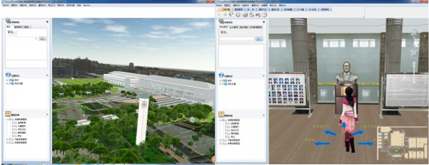
室内地图与场景重建
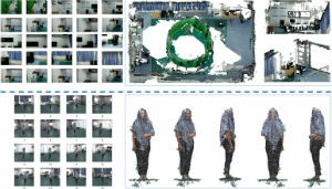
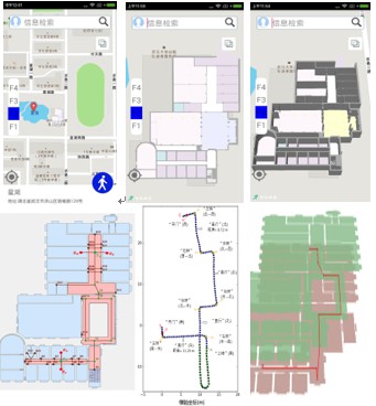
室内定位与导航
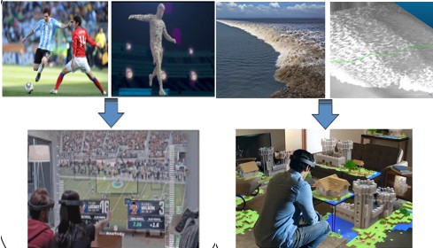
地理场景VR&AR
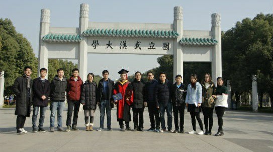
科研团队
师资
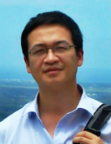 |
熊汉江,博士,教授,博士生导师。长期从事地理信息系统理论方法的研究和软件平台开发工作。主要研究兴趣为:地理空间数据信息可视化、海量空间数据网络服务与快速传输及三维模型快速重建等。 |
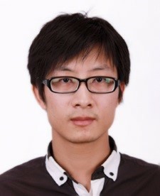 |
郑先伟,工学博士,副研究员。长期从事地理空间三维建模与在线可视化的研究工作。研究兴趣包括:室内外场景理解、语义三维模型重建与增强现实表达、实时摄影测量与虚拟现实、智能位置服务等。 |
在读研究生
 |
 |
 |
|
博士研究生 马威 研究方向:室内多源信息融合可视化 |
博士研究生 周妍 研究方向:室内视觉定位与场景重建 |
硕士研究生 陈林 研究方向:地理场景现实增强 |
 |
 |
 |
|
硕士研究生 刘宁 研究方向:室内路径拓扑自动构建 |
硕士研究生 朱华晨 研究方向:序列图像的特征提取 |
硕士研究生 袁恒 研究方向:移动端室内外位置服务 |
 |
 |
 |
|
硕士研究生 张言言 研究方向:移动端三维地图引擎 |
硕士研究生 丁友丽 研究方向:基于图像的三维场景重建 |
硕士研究生 张展 研究方向:地理场景现实增强 |
主要学术与教学荣誉
主要科研课题
- 1、 十三五国家重点研发计划子课题“面向智能定位的室内GIS系统”,2016-06——2020-12,主持;
- 2、 测绘地理信息公益性行业科研专项“多源遥感数据精细三维全景建模技术与系统”,2015-01——2016-12,负责武汉大学子课题;
- 3、国家863计划子课题“全球海量空间数据可视化技术”,2015-01——2016-12,参与;
- 4、国家863计划子课题“基于互联网迭加协议的全息位置地图汇集融合技术”,2014-01——2015-12,参与;
- 5、 国家科技支撑计划“位置传感网与全息位置地图关键技术及应用“,2013-01——2016-12,参与;
- 6、 高分卫星专项课题“大规模空间数据高效球面可视化技术”,2011-06——2012-12,参与;
- 7、十一五国家863计划目标导向类课题“网络环境下分布式空间信息高效可视化技术”,2009-06——2012-12,主持。
主要学术成果
[1] Xianwei Zheng, Hanjiang Xiong, Jianya Gong, Linwei Yue. A morphologically preserved multi-resolution TIN surface modeling and visualization method for virtual globes[J]. ISPRS Journal of Photogrammetry and Remote Sensing, 2017, 129: 41-54. (SCI)
[2] Sheng Guo, Hanjiang Xiong, Xianwei Zheng, Yan Zhou. Activity Recognition and Semantic Description for Indoor Mobile Localization[J]. Sensors, 2017, 17(3): 649. (SCI)
[3] Yan Zhou, Xianwei Zheng, Hanjiang Xiong, Ruizhi Chen. “Robust Indoor Mobile Localization with a Semantic Augmented Route Network Graph.” ISPRS Int. J. Geo-Inf. 2017, 6(7), 221.
[4] Sheng Guo, Xiong Hanjiang, Zheng Xianwei. “A Novel Semantic Matching Method for Indoor Trajectory Tracking.” International Journal of Geo-Information, 2017, 6(7):197.
[5] Sheng Guo, Hanjiang Xiong, Xianwei Zheng , Yan Zhou. Indoor Pedestrian Trajectory Tracking Based on Activity Recognition. The 2017 IEEE Geoscience and Remote Sensing Symposium(IGASS 2017), 22-29 Jul.,2017, Texas.
[6] Yan Zhou, Xianwei Zheng, Hanjiang Xiong, Jianya Gong and Linwei Yue. Reconstructing Indoor 3D Model Based on Crowdsourced Images. The ISPRS Geospatial Week 2017 (Indoor 3D 2017), 18-22 Sep., 2017, Wuhan.
[7] Yan Zhou, Xianwei Zheng, Hanjiang Xiong, Jianya Gong. Semantic Map Based Mobile Indoor Localization. The 25th International Conference on Geoinformatics, 29 Jul.-8 Aug. 2017, Buffalo.
[8] Xianwei Zheng, Jianya Gong, Hanjiang Xiong, et.al. “Three-dimensional Reconstruction and Simulation of Tidal Bore from the High-frequency Sequence Images: A Case Study on Qiantang River, The Asia GIS Conference 2017.
[9] Wei Ma, Xianwei Zheng, Hanjiang Xiong. “Crowdsourcing Data Based Features Fusion for Indoor Scene using Single Image and 3D Model”, The Asia GIS Conference 2017.
[10] Xianwei Zheng, Hanjiang Xiong, Jianya Gong, Linwei Yue. "A Virtual Globe-Based Multi-Resolution Tin Surface Modeling and Visualization Method." ISPRS-International Archives of the Photogrammetry, Remote Sensing and Spatial Information Sciences (2016): 459-464.
[11] Xianwei Zheng, Hanjiang Xiong, Linwei Yue, Jianya Gong. “An improved ANUDEM method combining topographic correction and DEM interpolation”, Geocarto International vol.31(5), pp492-505, May. 2016. (SCI)
[12] 郑先伟,熊汉江,龚健雅. 面向虚拟地球的海陆地形多尺度TIN建模及可视化方法,武汉大学报(信息科学版),2016, DOI10.13203/j.whugis20150678.
[13] 卢战胜, 熊汉江. 基于 GPU 的三维地下管网实时构建与可视化[J]. 测绘与空间地理信息, 2016, 39(2): 39-42.
[14] Xianwei Zheng, Hanjiang Xiong, Jianya Gong, Linwei Yue. “A robust channel network extraction method combine discrete curve evolution and skeleton construction technique”, Advances in water resources, vol.83, pp17-27, Sep. 2015. (SCI)
[15] Xianwei Zheng, Hanjiang Xiong, Jianya Gong, Linwei Yue. A robust channel network extraction method combining discrete curve evolution and the skeleton construction technique. Advances in Water Resources,2015, 83, 17-27.
[16] 戴雪峰, 熊汉江, 龚健雅. 一种三维城市模型多纹理自动合并方法[J]. 武汉大学学报: 信息科学版, 2015, 40(3): 347-352.
[17] 柯芬, 熊汉江, 戴雪峰. 一种基于体素的室内三维连通图自动生成算法[J]. 测绘与空间地理信息, 2015, 38(3): 34-37.
[18] 李秀娟, 郑先伟, 熊汉江. 离散曲线演化及等高线剖分山脊山谷线提取[J]. 测绘科学, 2015, 40(9): 107-110.
[19] 熊汉江, 李秀娟. 一种提取山脊线和山谷线的新方法[J]. 武汉大学学报: 信息科学版, 2015, 40(4): 498-502.
加入我们
也许你正在为自己新的征程寻找一个新的成长平台;
也许你正满怀激情和梦想,寻求具有挑战性的科研方向;
那么,优秀的你,请不要犹豫, 加入我们,
也许,一个正确的选择将为你打开科研之路的新的篇章