"Everything should be made as simple as possible, but not simpler."-Albert Einstein
Introduction of Dr.Zhixiang Fang

Dr. Zhixiang Fang is a Professor of State Key Laboratory for Information Engineering in Surveying, Mapping and Remote Sensing(Liesmars), Wuhan University. His fields of expertise and research interests include human behavior modeling in sapce-time GIS, pedestrian navigation and transport geogoraphy. Dr. Fang earned his Ph.D and M.Sc.degrees from Wuhan University.


Research interest
My research interests includes
- Human dynamics observation and application
- Spatialtemporal sensing and space-time GIS
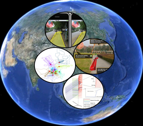
- Spatial cognition and smart pedestrian navigation
Special issues
 《Environment and Planning B: Urban Analytics and City Science》“Prospects and Challenges of Integrating Environmental and Human Observations for Smart Cities”
 《Remote Sensing》"Human-oriented observation for supporting effective decision-making in governance and public service"
- 《Remote Sensing》"Remote Sensing for marine environmental disaster response"
 《Smart Cities》"Big Data-Driven Intelligent Services in Smart Cities"
 《Journal of Geo-Information Science》
International Symposium
 18th International Symposium on Web and Wireless Geographical Information Systems(W2GIS 2020)
Experiences


1.2014-now
Professor,State key Laboratory of Information Engineering in Surying Mapping and Remote Sensing

2,2015-2,2016
Adjunct Professor, University of Tennessee
12.2008-12.2013
Associate Professor,State key Laboratory of Information Engineering in Surying Mapping and Remote Sensing
11,2007-11,2008
Postdoctoral, University of Tennessee

12,2006-11,2007
Lecturer,State key Laboratory of Information Engineering in Surying Mapping and Remote Sensing
Awards

- Oct., 2021,Big data methods, techniques and applications for the prevention and control of major respiratory infectious disease outbreaks, Special award for Science and Technology Progress Award of China Surveying and Mapping Institute
- Nov., 2019,Big data-driven urban activity dynamics detection and spaiotemporal service technologies,the Second Prize of Science and Technology Award of Ministry of Education
- Nov., 2018,Visual navigation technique and application based on spatial sensing of integrated indoor and outdoor environment,the Second Prize of Science and Technology Award of Hubei Province
- Nov.,2014,Network-based navigation and logistics under complicated dynamic transportation network environment, the First Prize of Science and Technology Award of China Geographic Information Industry Association
- Nov.,2010,the outstanding instructor award of Chinese college studentsGIS software development contest
- Dec.,2009,"Multiscale Modeling of spatial data and network progressive transmission",the Natural Science Award of Hubei Province
- Oct.,2004,"development and industrialization of Navigation electronic map and intelligent navigation software",Science and Technology Progress Award of China Surveying and Mapping Institute
Projects

- 2020.1-2020.12, 18th International Symposium on Web and Wireless Geographical Information Systems(W2GIS 2020),Project supported by the National Natural Science Foundation of China(NSFC)
- 2018.1-2022.12, Relative pedestrian navigation method for urban scene environments ,Project supported by the National Natural Science Foundation of China (NSFC)
- 1,2014-12,2017. Indoor and outdoor pedestrian navigation model based on the scene saliency,Project supported by the National Natural Science Foundation of China (NSFC)
- 1,2010-12,2012.Emergency space-time path allocation algorithm of multiple moving objects based on the airspace up a,Project supported by the National Natural Science Foundation of China(NSFC)
- 1,2008-12,2010. The reasoning Spatial and temporal evolution algorithm of network moving objects based on GIS-T road, Project supported by the National Natural Science Foundation of China(NSFC)
- 1,2013-12,2017,Using mobile phone data to analyze interactions between group activities and urban spaital structures for optimization of facility locations. Project supported by the National Natural Science Foundation of China(NSFC)
- 2017.7-2021.6, Comprehensive transportation integrated planning, construction and operation supervision of Urban Agglomeration Economic Zone,Project supported by National key R & D plan